Task 4: Detailed analysis of accidental scenarios
Under the scope of task 4 two different approaches have been adopted with the objective of better understanding and characterizing maritime accidental scenarios and relevant risk influencing factors. One research line has focused on a large data set of ship collision accidents that have occurred worldwide (Antão et al. 2021) whereas the alternative approach has identified non-accident critical events from maritime traffic data, such as near collisions, and has characterised the relationship between these critical events and the characteristics of the local maritime traffic (Rong et al. 2021).
Regarding the actual accident-based approach, data from 746 collision accidents from the period between 2006-2016 worldwide have been analysed in detail. The data are retrieved from the Global Integrated Shipping Information System of the International Maritime Organization consisting of 1276 ships involved in the collisions. The period of the study covers 5 years, prior and after the introduction of the New Inspection Regime in 2011, to identify potential impacts of its introduction into the collision accident rate. Additionally, information from the European Quality Information System on the world fleet statistics is also retrieved to estimate the risk levels.
Two of the main objectives of the study are to identify the circumstances in which collision events developed and to identify collision Risk Influencing Factors, fundamental for the development of risk models and the estimation of the risk levels of a given ship in a given scenario. In the study several variables are analysed, namely, ship type, flag, GT, consequences, classification society, ship length, etc. towards the abovementioned objectives. Findings show that General Cargo (17%), Container ships (16%) and Bulk Carriers (14%), represent nearly 50% of the ships involved in collisions. Typically, small size ships are involved in these occurrences, although this trend is changing. It is worth notice that visibility is still a paramount factor to the probability of collision. Furthermore, and in order to estimate the collision probability per ship type and year, information concerning the fleet at risk is retrieved from the Equasis information system for the period in consideration. Results show that Bulk Carriers, Container ships and Ro-Ro Cargo vessels are the three ship types presenting higher probabilities of collision.
The analysis performed in this study provided the basis for a later identification of collision Risk Influencing Factors, fundamental for the development of risk models and the estimation of the risk levels of a given ship in a given scenario.
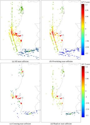
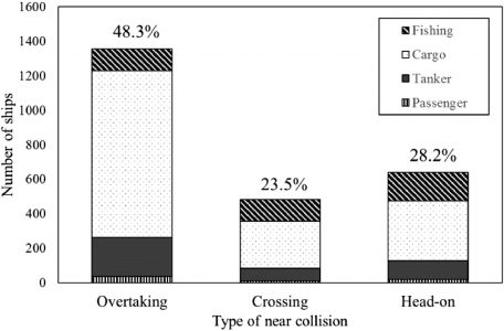
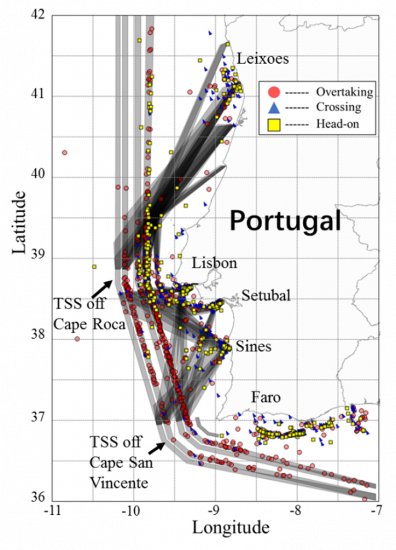
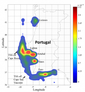
Studies on the quantitative analysis of the relationships between traffic characteristics and maritime traffic risk from spatial perspective are scarce. Several studies have been conducted covering the aspects of maritime traffic analysis and characterization from AIS data, whereas others are focused mainly on the collision risk using the concepts of near collisions, collision candidates or other non-accident critical events. However, the correlation of the traffic characteristics and the near collision is typically not assessed in a systematic way. This research gap has been addressed by Rong et al. (2021) who have investigated and quantified the correlation between near collision hotspots and the maritime traffic characteristics off the continental coast of Portugal.
The Moran’s I and Getis-Ord Gi spatial autocorrelation methods are used to determine whether near collisions show spatial clustering from global and local perspectives. The application of the developed approach to Automatic Identification System data of the maritime traffic off the coast of Portugal shows that there are several hotspots where the density of ship near collisions is relatively high. A co-occurrence analysis is then conducted to relate the near collision hotspots with selected local maritime traffic characteristics such as the average ship speed, speed dispersion, degree of speed acceleration, ship route overlaps and degree of angular deviation from ship route centreline. The identification of near collisions clusters and the assessment of the correlation of ship near collision hotspots with the maritime traffic features provide a means for improving maritime safety and reducing the occurrence of ship-ship collisions.


