Task 1: characterization of maritime traffic and safe routes for ships
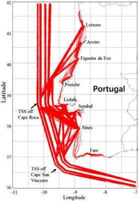
The Portuguese national marine jurisdiction is crossed by a complex maritime traffic network: ships bound to and leaving from national ports, fishing vessels, pleasure craft, traffic from the Mediterranean to North America, from Africa to northern Europe, and from northern Europe to South America. It is unrealistic to manually trace such enormous number of moving objects, classify them according to their destination and to identify the abnormal behaviours along the different ship routes. It is therefore highly desirable to develop automatic tools to analyse and evaluate the behaviour of all ships. To fill this gap, MoniRisk proposes a data-driven ship route extraction method and graph-based representation of the maritime traffic.
To identify and understand the maritime traffic patterns, the maritime traffic route extraction is proposed. This extraction is based on historical AIS data and consists of grouping ship trajectories that follow the same itinerary (i.e., from traffic departure areas to arrival areas). To identify departure-arrival areas, two types are considered: (1) “port”, “anchorage area” or “fishing area” and (2) “entry/exit” areas. When ships are stationary in a port, or at an anchorage area, they keep transmitting AIS messages reporting zero speed. Therefore, the first type departure-arrival areas can be shaped by clustering the stationary points. Besides, as the study area is bounded by a geographic box in which ships enter or exit, the intersections of the ship trajectories with the box boundaries are also determined and considered as enter/exit points of the ships’ trajectories. In other words, the geographical areas at which ships entry in and exit out the study area are also considered as departure-arrival areas. Like ship static positions, these enter and exit points are also clustered to define departure-arrival areas of motion patterns at the study area. Thus, in order to define departure-arrival areas, stationary points and entry/exit points are clustered by the OPTICS (Ordering Points To Identify the Clustering Structure) algorithm.
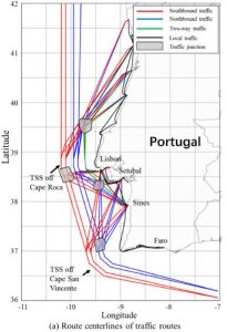
Once the concept of itinerary has been formalised, ship trajectories following the same itinerary are grouped together. A finite set of ship trajectories within a specific motion pattern is key to understand the characteristics of ship motion behaviour. To better capture ship travelling behaviour, a maritime traffic network abstraction providing a compact representation of the maritime traffic is proposed, based on a directed graph whose nodes represent waypoint areas and maritime junction areas and edges represent navigational routes. A waypoint area refers to an area in which ships change their motion behaviour (e.g., the ship speed or course change significantly). A waypoint area is automatically identified by clustering turning points detected in ship trajectories (Rong et al. 2020). A junction area, in the context of maritime traffic, is a geographical area at which two or more routes converge or diverge. The junction area is automatically identified by detecting overlaps of turning points.


