Task 5: Integrated system for traffic monitoring and maritime risk assessment
The main aim of Task 5 is a prototype of a platform for maritime traffic analysis that integrates the computational tools.
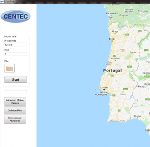
The prototype platform includes three main computational tools that have been implemented in C# (C-Sharp) programming language with the following functions: 1. AIS data decoding, cleaning, compression and extraction of maritime traffic patterns from historical AIS data; 2. Assessment of the spatial distribution of ship-ship collision risk; and 3. Automatic detection of abnormal ship behaviour. Each function requires historical AIS data to be imported first, the user can simply click the “File” button and select the AIS data file or input IP Address to connect database. Once the AIS data is imported correctly, then the user can execute the three functions by click the corresponding buttons.
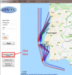
When analysing the ship trajectories over a period of time, the general motion patterns of ship trajectories that follow a similar route are learned using clustering techniques. The main motion patterns are determined based on the analysis of AIS data. The computational tool starts from identifying origin-destination areas (represented by grey polygons) in the study area based on the DBSCAN algorithm. Then, the ship trajectories that follow the same itinerary, e.g., from an origin area to a destination area, are grouped together. The route centreline and route boundaries (represented by red, blue and green polygon) are estimated by statistical analysis of ship trajectories within the ship route based on DTW algorithm.
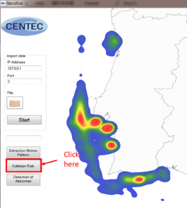
To gain insight into the spatial distribution of the collision risk, the Kernel Density Estimation method is applied to derive spatial density maps of the collision risk off the continental coast of Portugal. For detecting near collision scenarios, ship domains are defined for all ships at all-time steps, and the encounter of ships is defined as a near collision once the ship domain violation occurs. Then, KDE method is adopted to estimate the spatial density distribution of near collision scenarios on the study area. It should be mentioned that the map overlap can be changed to “Google Map” or “Coastal Map” to show the results.
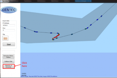
A data-driven method for ship anomaly detection is proposed and implemented. The approach is derived from a maritime traffic normalcy model that is constructed based on historical ship trajectories provided by Automatic Identification System data. Positional and motion abnormal behaviours are formulated probabilistically based on statistical models of the lateral distribution of the ships’ trajectories and their motion characteristics, such as, speed and course changes along the routes. The Figure beside shows a case of ship abnormal behaviour detected by this tool.


